
Iceland – The land of fire and ice
We admit that this term is a bit worn out, but it is the most appropriate one you can find about this country.
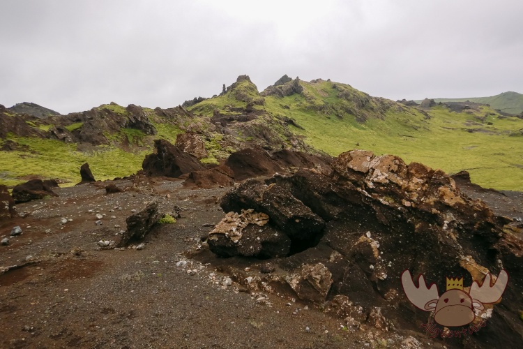
The island state far to the north is characterized by exactly these two things – lots of ice and even more volcanoes. But contrary to its name, Iceland is much more than a barren landscape. It seems as if there is no one Icelandic landscape, but rather a new world opens up after every bend.
If you’re curious, be sure to save a spot on your travel list and see it for yourself.

Many travelers consider Iceland to be one of the destinations that you must visit at least once in your life – and rightly so.
The Atlantic island, which is only slightly larger than Austria, is far more diverse than the name would suggest.

The best way to explore the country is by car. Either you get a rental car or you visit Iceland with your own vehicle via the ferry route from Hirtshals in Denmark. Although this route definitely takes longer than traveling to the diverse island in the Atlantic by plane, it also offers the chance to visit the small archipelago of the Faroe Islands along the way. The ferry trip with the MS Norröna starts on Saturday in Hirtshals (Denmark) and, with a short stopover on Monday in Tórshavn (Faroe Islands), arrives on Tuesday in Seyðisfjørður (Iceland). The exact timetable and the applicable tariffs can be found on the Smyrilline homepage.
However, those who prefer not to travel by ship have the option of heading to the international airport in Keflavik, near the Icelandic capital Reykjavík, and from there get to know the country and its people. This is also the best way to get as many experiences as possible from Iceland with limited time. Within an hour’s drive of Reykjavík, the country’s most important (and easiest to reach) attractions are located in the so-called Golden Circle.
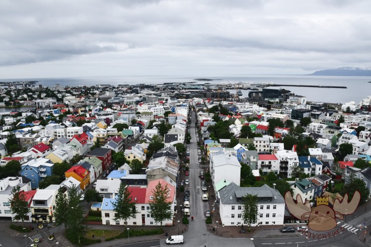
Reykjavík | Ausblick auf das Stadtzentrum vom Turm der ca. 74 Meter hohen Hallgrímskirkja. – View of the city centre from the tower of the approx. 74-metre-high Hallgrímskirkja. 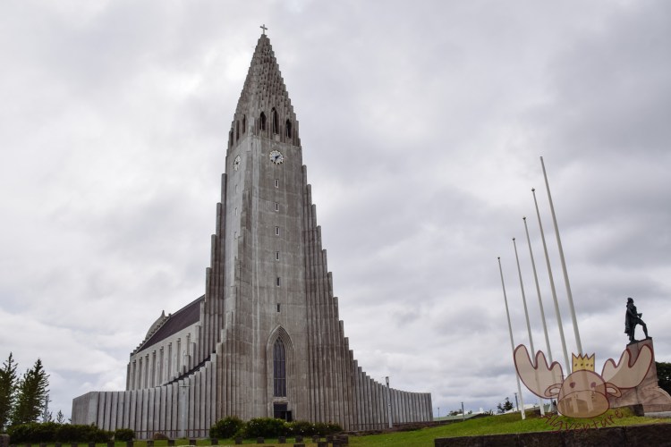
Reykjavík | Die Hallgrímskirkja ist eine evangelisch-lutherische Pfarrkirche im Zentrum von Reykjavík und das größte Kirchengebäude Islands. – Hallgrims Church is an Evangelical Lutheran church in the centre of Reykjavík and the largest church building in Iceland. 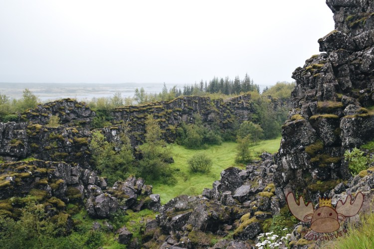
Þingvellir | Früher suchten die Menschen in diesen Tälern Schutz vor der Witterung wenn sie sich für das Alþingi versammelten. – In the past, people in these valleys sought shelter from the weather when they gathered for Alþingi. 
Bláa Lónið | Die Blaue Lagune gehört mittlerweile zum Fixpunkt vieler Island-Reisenden. Daher ist es sehr ratsam sich einen Zeitslot im Voraus zu buchen. – The Blue Lagoon is now a fixture for many travelers to Iceland. It is therefore highly advisable to book a time slot in advance. 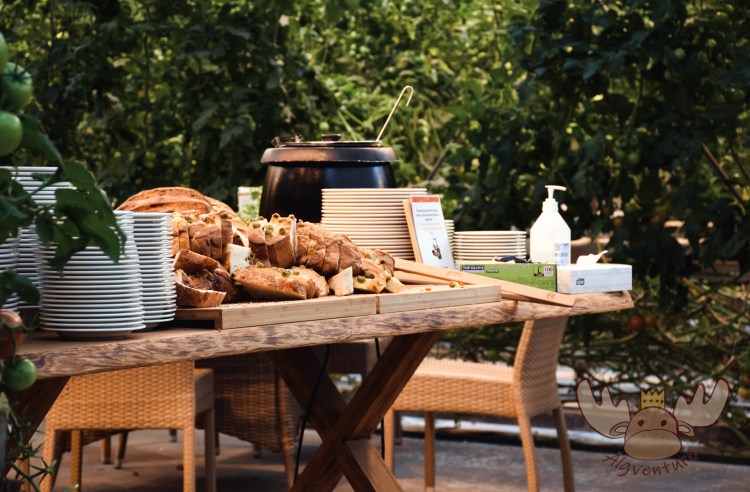
Friðheimar | Das Glashaus bietet ein einmaliges Ambiente um eine Frucht zu genießen, die man nicht in Island erwarten würde. – The Glasshouse offers a unique ambience to enjoy a fruit that you would not expect in Iceland. 
Seljalandsfoss | Der Seljalandsfoss befindet sich nur wenige Kilometer außerhalb der Isländischen Hauptstadt und wird im Zuge einer Golden Circle Tour gerne von Touristen besucht. – Seljalandsfoss is located just a few kilometers outside the Icelandic capital and is often visited by tourists as part of a Golden Circle Tour. 
Geysir | Älgbert beobachtet in sicherer Entfernung von einem nahegelegenen Hügel aus den spektakulären Ausbruch des Strokkur. – Älgbert watches the spectacular eruption of Strokkur from a safe distance from a nearby hill. 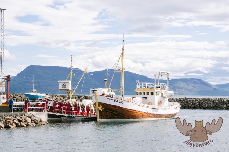
Whale Watching | 
Vestfirðir | In Vestfirðir leben mehr Schafe als Menschen. – There are more sheep than people in Vestfirðir. 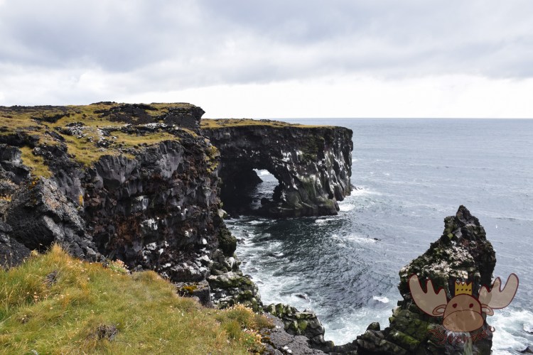
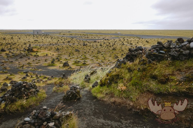
Snæfellsjökull | Am Westende der Halbinsel Snæfellsjökull beeindruckt die Steilküsten mit ihren Vogelkolonien. – At the western end of the Snæfellsjökull peninsula, the cliffs with their bird colonies are impressive. 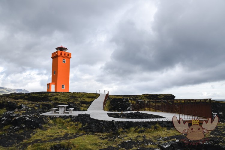
Snæfellsjökull | Am Westende der Halbinsel Snæfellsjökull erhebt sich der orange Leuchtturm Svörtuloft am Rande der rauen Klippen. – At the western end of the Snæfellsjökull peninsula, the orange Svörtuloft lighthouse rises from the edge of the rugged cliffs. 
The Arctic Henge
However, if you really want to get to know Iceland, you should definitely explore the country beyond the Golden Circle. No matter which side you come to the island from, the best way to do this is to drive along the ring road (Hringvegur or Þjóðvegur 1) and keep turning left and right and following the side roads for a few kilometers. However, it should be noted here that Icelandic roads can only partially be compared with Central European ones. The ring road has been completely paved since August 2019 and, with the exception of a few bridges, has been expanded to two lanes, but this does not apply to all of Iceland’s secondary roads. For example, some parts of the ring road near Reykjavík resemble a well-developed motorway, but other roads are more comparable to dirt roads. If you want to be sure of the quality of your preferred route before you start your journey, you should visit the website of the Icelandic Road and Coastal Administration or its interactive map to avoid any surprises. The roads in the highlands are generally only suitable for, and should only be used by, very off-road vehicles.
You can get more information on VisitIceland and plan your road trip through Iceland on upplifdu.is.
Snæfellsjökull | Älgbert auf dem Weg zur Ingjaldshólskirkja, der ältesten Steinkirche des Landes. – Älgbert on the way to Ingjaldshólskirkja, the oldest stone church in the country. 
Snæfellsjökull | Arnarstapa verdankt seinen Namen dem kegelförmigen Berg Stapafell, auf dem die Seeadler Nester bauen. – Arnarstapa owes its name to the cone-shaped mountain Stapafell, where the sea eagles build their nests. 
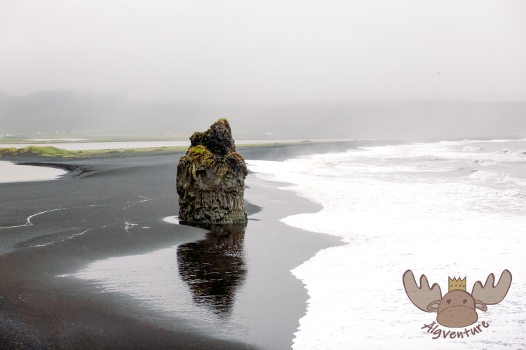
Vík í Mýrdal | Die Víkurkirkja thront über dem kleinen Ort mit seinen 450 Einwohnern. – Víkurkirkja is located on a hill above the small town with 450 inhabitants. 
Snæfellsjökull | Die kleine Búðakirkja-Holzkirche ist aufgrund der besonderen Lage die am meisten fotografierte Kirche des Landes. – The small Búðakirkja wooden church is the most photographed church in the country because of its special location. 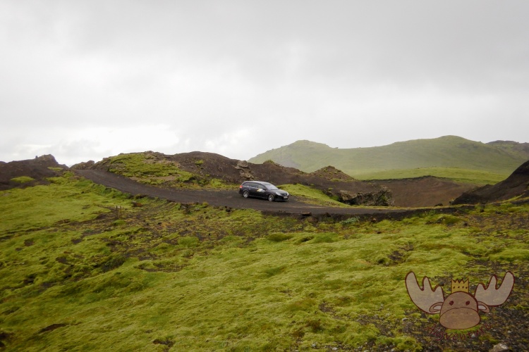
Þakgil | Weiter oben verändert sich die Straße die sich eng und verschlungen den Weg nach oben bahnt. – Further up, the road changes, which narrows and winds its way up. 
Fjaðrárgljúfur | Der Fluss Fjaðrá bahnte sich im Laufe der Jahrtausende seinen Weg durch das Palagonitgestein. – The Fjaðrá river carved its way through the palagonite rock over thousands of years. 
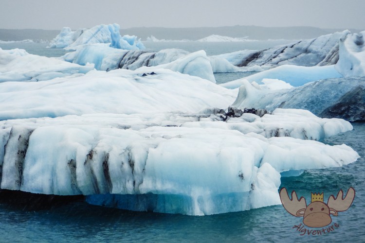
Jökulsárlón – Das schön blau schimmernde Eis ist mehrere Tausend Jahre alt. | The beautifully blue shimmering ice is several thousand years old.
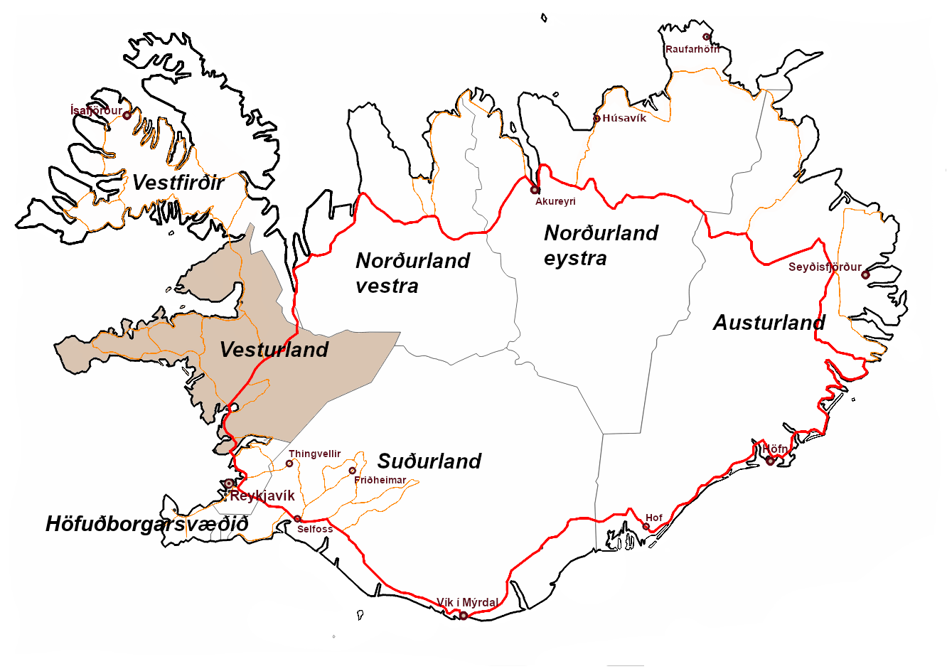
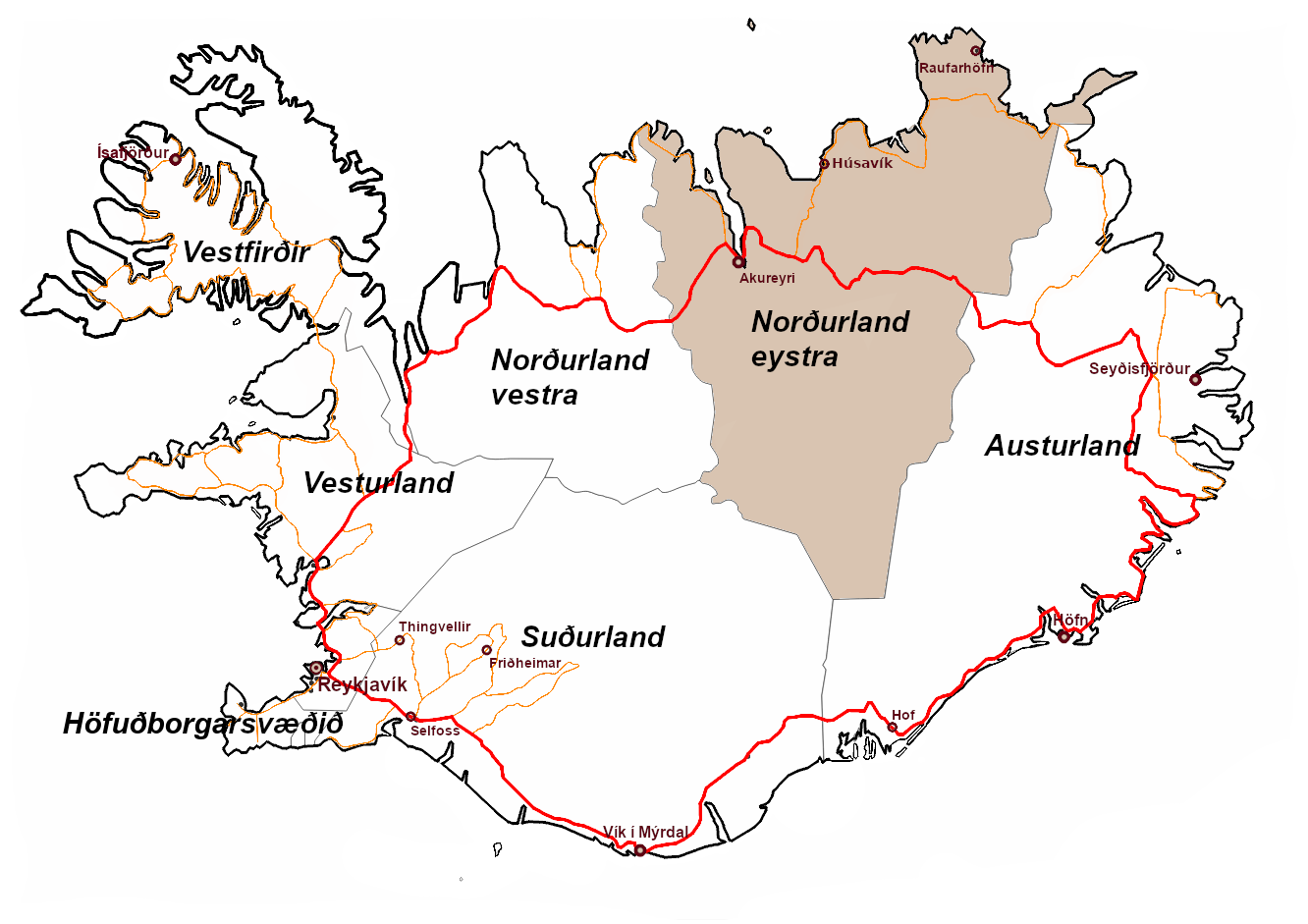
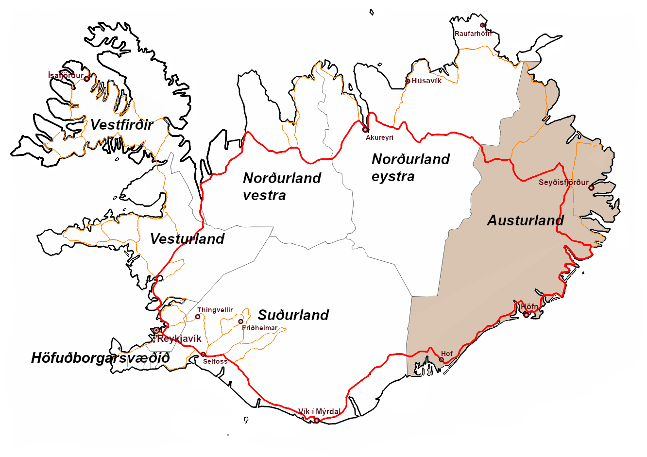
To provide a better overview, we have divided Iceland into several regions, similar to the current administrative districts. This allows the information provided to be better filtered by region. At the bottom of this page there is also an overview map with the most important sights. If you click on one of the symbols on the map, you will find out everything you need to know before your visit.
Höfuðborgarsvæðið
 Höfuðborgarsvæðið, or capital region in English, is the smallest region surrounding Reykjavík with Keflavík International Airport. We have taken the liberty here of combining the capital region with the also very small Suðurnes region.
But this region has much more to offer. After all, around two thirds of Iceland’s population live here. A third of all Icelanders live in Reykjavík alone. Multi-story houses can also be seen in the capital region – a rarity in the rest of the country.
The name Reykjavík, which the first settlers gave their new city, is derived from the nearby hot springs and the smoke they give off and means something like steaming bay. It is therefore obvious that hot springs near the city have been used for many years.
The Blue Lagoon (Bláa lónið) is located not far from the airport and about 50km from the capital. Deep in the earth, the water, volcanically heated to around 240°C, mixes with minerals contained in the volcanic rock on its way to the surface. Enriched with silica and algae, it is available to bathers looking for relaxation at a pleasant 38°C to make themselves comfortable in the milky-blue liquid and enjoy a healthy drink at the bar. It’s hard to believe that this is actually the „wastewater“ from the nearby Svartsengi thermal power plant.

Bláa Lónið | Im etwa 38°C warmen Wasser lässt es sich gut aushalten. – It’s easy to relax in the water, which is around 38°C warm. 
Bláa Lónið | Älgbert genießt die Auszeit und entspannt gemütlich am Beckenrand. – Älgbert enjoys the time out and relaxes comfortably at the pool. 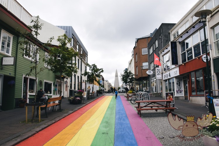
Reykjavik | Regenbogenstraße auf dem Weg zur Hallgrimskirkja. – Rainbow Street on the way to Hallgrimskirkja. 
Reykjavik | Das 2011 neueröffnete Opern- und Konzerthaus Harpa in der isländischen Hauptstadt Reykjavik – The Harpa Opera and Concert House in the Icelandic capital Reykjavik, reopened in 2011. 
Reykjavik | Die Denkmallokomotive Minør in der isländischen Hauptstadt. – The Minør monument locomotive in the Icelandic capital. 
Reykjavik | Möwen sitzen am Brückengeländer des Sees Reykjavíkurtjörn. – Seagulls sitting on the bridge railing of Lake Reykjavíkurtjörn.
The capital region offers the ideal starting point for exploring the southwest of Iceland. Many sights can be reached within a short drive – inside and outside Reykjavik. There is a wide range available in the capital. From the Harpa Concert Hall with its modern architecture to the more curious such as the Penis Museum, there is certainly something for everyone. You can find out more about the Golden Circle in the article about Suðurland below. You can find information about current events on VisitReykjavik and VisitReykjanes.
Vesturland
Vesturland is a region with impressive natural landscapes. The majestic Snæfellsjökull glacier, which covers a dormant volcano and whose summit you can take a tour of, is at home here, as is Europe’s second largest glacier – Langjökull.
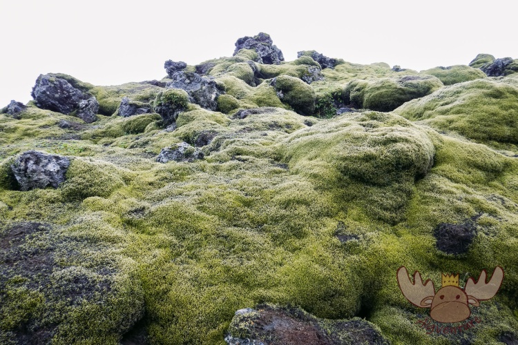
The Snæfellsjökull National Park, which has existed since 2001, covers 170km² of the western part of the Snæfellsnes peninsula and is intended to protect the unique flora and fauna. Although the soil is made of porous volcanic stone, a large number of mosses have settled there and need to be protected. Numerous marked hiking and riding trails crisscross the park, which should not be left under any circumstances. They often follow the old mule tracks, which were the only connecting routes here until the beginning of the 20th century.
About two hours‘ drive from Reykjavik, a landscape as one imagines for Iceland unfolds before the visitor’s eyes. With a population density of just 1.65 inhabitants/km², Vesturland seems pretty empty, especially compared to the capital region. This is one reason why this region is also very popular with Icelanders for excursions. Here it is possible to experience the beauty of nature (almost) without people.
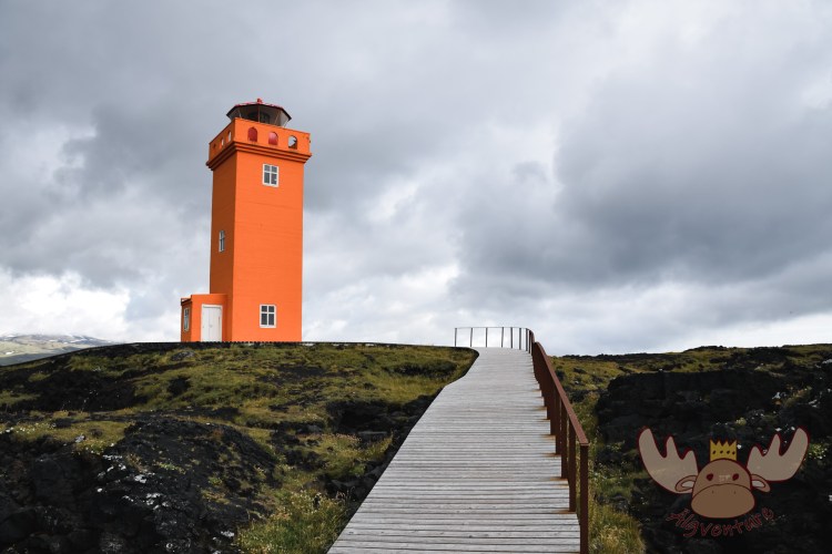
Snæfellsjökull | Am Westende der Halbinsel Snæfellsjökull erhebt sich der orange Leuchtturm Svörtuloft am Rande der rauen Klippen. – At the western end of the Snæfellsjökull peninsula, the orange Svörtuloft lighthouse rises from the edge of the rugged cliffs. Snæfellsjökull | Am Westende der Halbinsel Snæfellsjökull beeindruckt die Steilküsten mit ihren Vogelkolonien. – At the western end of the Snæfellsjökull peninsula, the cliffs with their bird colonies are impressive. 
Snæfellsjökull | Entlang der Küste verläuft die Straße „Útnesvegur“, die beeindruckende Ausblicke auf das Land ermöglicht. – The „Útnesvegur“ road runs along the coast, offering impressive views of the countryside. 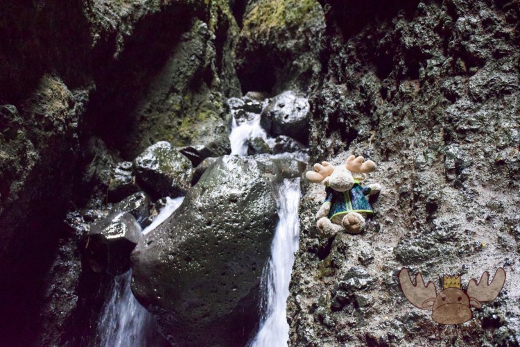
Snæfellsjökull | Älgbert klettert in die Schlucht Rauðfeldsgjá im Berg Botnsfjall auf der Halbinsel Snæfellsnes. – Älgbert climbs into the Rauðfeldsgjá gorge in Mount Botnsfjall on the Snæfellsnes peninsula. 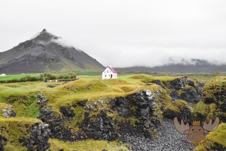
Snæfellsjökull | Ausblick vom kleinen Hafen im Fischerort Arnarstapa auf das am Hügel gelegene „einsame Haus“. – View from the small harbour in the fishing village of Arnarstapa to the „lonely house“ situated on the hillside. Snæfellsjökull | Älgbert auf dem Weg zur Ingjaldshólskirkja, der ältesten Steinkirche des Landes. – Älgbert on the way to Ingjaldshólskirkja, the oldest stone church in the country. 
Snæfellsjökull | Eine kleine Insel vor dem Fischerort Arnarstapa mit in Island einheimischen Vögeln. – A small island off the fishing village of Arnarstapa with birds native to Iceland.
For more up-to-date information about upcoming events that are not shown on our website, you can also check out west.is.

Vestfirðir

Vestfirðir in the northwest of the country is the least populated area in Iceland. There isn’t even one Icelander per square kilometer here. On the one hand, this is due to the migration of the population due to limited work opportunities outside of fishing and, on the other hand, due to the rugged and inhospitable landscape.
Accessibility is also a reason why many Icelanders move. Many roads are only gravel roads and are hardly passable, especially in winter. In the cold season, some parts of the Westfjords are not inhabited.
Even in heavy or long periods of rain, the condition of the paths can deteriorate significantly. The current weather and road warnings can be found on the road.is website.
Vestfirðir | In Vestfirðir leben mehr Schafe als Menschen. – There are more sheep than people in Vestfirðir. 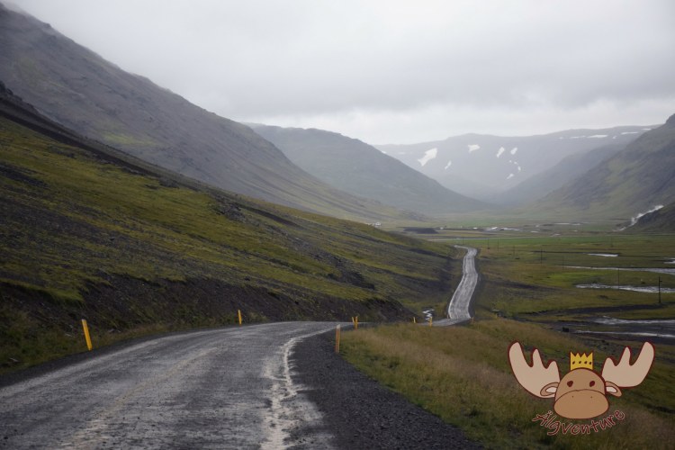
Vestfirðir | Gerade die Straßen auf der Südseite der Halbinsel sind meistens nicht asphaltiert. – The roads on the south side of the peninsula in particular are mostly not asphalted. 
Vestfirðir | Viele Brücken sind nur einspurig ausgebaut. – Many bridges only have one lane. 
Vestfirðir | Toyota Hilux 
Vestfirðir | Auf den Straßen Vestfirðirs wird das Auto auf alle Fälle etwas dreckig. – The car will definitely get a little dirty on the streets of Vestfirðir. 
Vestfirðir | So sieht das Ergebnis aus, wenn man isländische Straßen bei Regen befahren möchte. – This is what the result looks like if you want to drive on Icelandic roads in the rain.
If you don’t let the accessibility put you off, you’ll find an almost deserted world just waiting to be explored. You can do this either on the numerous hiking trails or on the water. Many fishermen offer tours out to sea so you can catch fish yourself.
You can find out more about current events at westfords.is.
Norðurland vestra
 The northern region of Norðurland is the largest of Iceland’s administrative districts. Therefore, officially, it was divided into East and West. For a better overview, we have also adopted this classification.
The western part of Norðurland is characterized by small fishing towns on the coast and small hamlets in the interior. As with the northwestern neighboring region of Vestfirðir, the population density here is below one. You get the impression that there are more sheep than people living here.
For nature lovers, these are the perfect conditions to experience deserted landscapes on hikes. Be it to natural hot springs where you can bathe or to observe nature and the animals that live there.
Illugastaðir on the Vatnsnes Peninsula is home to one of Iceland’s best seal watching spots. The seals stay there almost all year round, so you can observe the animals undisturbed on the hiking trail right next to the sea. A large number of arctic terns and eider ducks also nest in the surrounding rugged coastal cliffs.
Another landmark on the Vatnsnes peninsula is Hvítserkur, a 15m high basalt island in the shape of a dragon visible from a black sand beach. This rock formation is one of the most photographed subjects in the region and can therefore be cited as a landmark.

Norðurland eystra
 When traveling around Iceland, we recommend leaving the ring road at Varmahlíð and following road 76. Although the ring road leads through a picturesque valley to Akureyri, road 76 runs along the coast to Siglufjörður. In addition to the breathtaking scenery on the north coast of Iceland, the small fishing town is a central point in the country’s recent history.
Many species of fish are found around the coasts of Iceland. When these rich fishing grounds began to be exploited industrially, large processing plants were built in the small villages on land. Many Icelanders moved to the once small fishing village. The small but well-known museum „Síldarminjasafn Íslands“ tells the story of these people in historical buildings.

Síldarminjasafn Íslands | Einfahrt in das Fischerdorf Siglufjörður – Entrance to the fishing village of Siglufjörður 
Síldarminjasafn Íslands | Das Museum ist auf mehrere historische Gebäude aufgeteilt. – The museum is housed in several historical buildings. 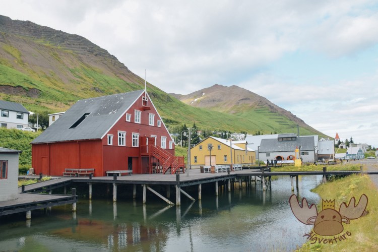
Síldarminjasafn Íslands | Im alten Wohnheim, Verpackungshaus und Maschinenraum des Hafens von Siglufjörður ist das Museum untergebracht. – The museum is housed in the old dormitory, packing house and engine room of the port of Siglufjörður. 
Síldarminjasafn Íslands | Siglufjörður war einer der wichtigsten Heringshafen Islands. – Siglufjörður was one of Iceland’s most important herring ports. 
Síldarminjasafn Íslands | Das Schiff „STEINI VIGG“ liegt im Hafen von Siglufjörður – The ship „STEINI VIGG“ is moored in the harbor of Siglufjörður
Continuing to follow the “75” and turning onto the “82”, the route to Akureyri now leads along the beautiful Eyjafjörður. This approximately 60 kilometer long fjord is the longest in Iceland and the perfect starting point to see whales in their natural habitat. These large marine mammals use the wide fjord to seek shelter. It can happen that these wonderful animals venture as far as Akureyri. Many whale watching tours also start from there, but we recommend starting from further north, for example from Dalvik or Hauganes, as the whales are more often near the sea than at the end of the fjord.

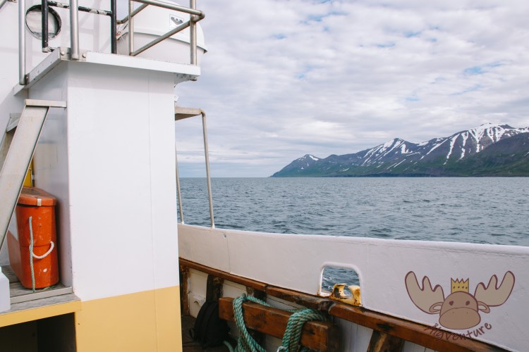
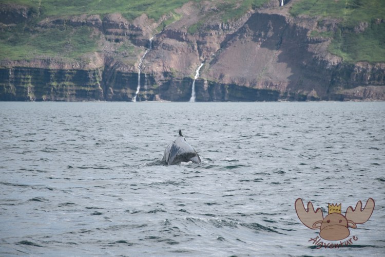


However, the real whale capital of Norðurland is Húsavík. With just over 2,300 inhabitants, the town is large by Icelandic standards and is the administrative headquarters and formerly an important starting point for whaling. The large Skjálfandi Bay on which Húsavík is located was already used for wintering by the Vikings coming from Scandinavia. The natural protection and location make Húsavík the perfect starting point for fishing – sometimes for whales. When industrial fishing began to take hold here, the small fishing town grew quickly. As in Siglufjörður, where the main fishing activity was herring, the population multiplied in a short time. Where only around 300 people lived in 1900, by 1970 there were almost 2,000. Most of them were employed in fishing and whaling. Today the people of Húsavík no longer fish for whales, but this large marine mammal still shapes the place in a different way. Many excursion boats also leave from Húsavík so you can watch the whales up close. In the whale museum “Hvalasafnið á Húsavík” you can learn more about the gentle giants of the sea and their importance for the people of Iceland.
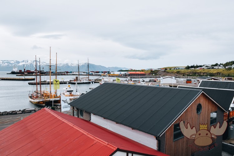
Húsavík | Wo sich einst viele Walfangschiffe im Hafen von Húsavík tummelten, liegen heute hauptsächlich kleinere Fischerboote und Ausflugsschiffe. – Where there were once many whaling ships in the harbor of Húsavík, today there are mainly smaller fishing boats and excursion ships. 
Húsavík | Im Museum werden die Unterschiede und Gemeinsamkeiten der Wal- und Delfinarten den Besuchern näher gebracht. – In the museum, the differences and similarities between whale and dolphin species are explained to visitors. 
Húsavík | Der Größenvergleich zwischen Wal und Reiseälg fällt eindeutig zugunsten des Meeressäugers aus. – The size comparison between whale and our traveling Älg is clearly in favor of the marine mammal.
Like Akureyri, Húsavík is a perfect starting point to explore the region around Lake Mývatn. The name Mývatn means mosquito lake in English, and this is a perfect description of the body of water, especially in the summer months. Due to its location in the area of the Krafla volcano system and the carbon dioxide it emits, the mosquitoes feel particularly comfortable here. For two weeks in summer, the many mosquitoes form real black columns on the shore of the lake. The reason for the abundance of insects is that the shallow lake is fed by underground hot springs and therefore only partially freezes over in winter. Due to the many mosquitoes, the lake is rich in fish and a variety of different bird species – especially many different species of ducks, some of which only breed in this place in Europe.
The Krafla volcanic system is also responsible for some natural attractions around the lake. For example, the crater of Hverfjall is not far away, which you can climb and walk around the edge. The crater, which was created by a water vapor explosion about 2,500 years ago, has a diameter of about one kilometer and a height of 90-150 meters. The sheer power that can come from a volcano becomes clear here. In Iceland, many geothermal power plants are trying to use at least a small part of this power potential for people. Anyone using the road to the top of Krafla will drive directly past the famous lonely shower fed by hot springs and the Krafla power plant. Several hiking trails lead from the parking lot there through the lava fields. These must not be left under any circumstances, otherwise there is a danger to life.
At the foot of the mountain and conveniently located right next to the ring road you can also visit the boiling mud pools “Hverarönd”. An almost unreal world in which everything seems dead.

Hverfjall | Mývatn 
Hverfjall | Der Krater hat einen Durchmesser von etwa 1000 Metern. – The crater has a diameter of around 1000 meters. 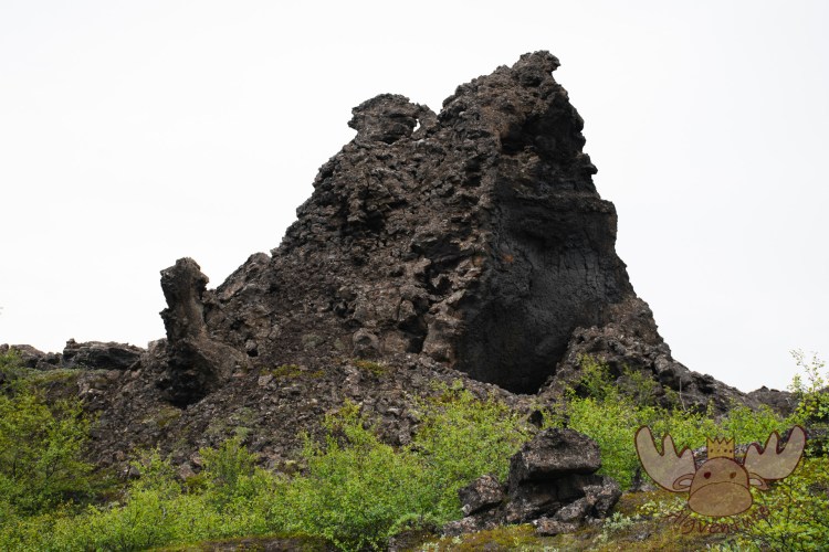
Dimmuborgir | Dimmuborgir heißt übersetzt so viel wie „Dunkle Burgen“, denn die Lavaformationen erinnern stark an verfallene Ruinen von Burgen und Türmen. – Dimmuborgir means something like “Dark Castles” because the lava formations are strongly reminiscent of the dilapidated ruins of castles and towers. 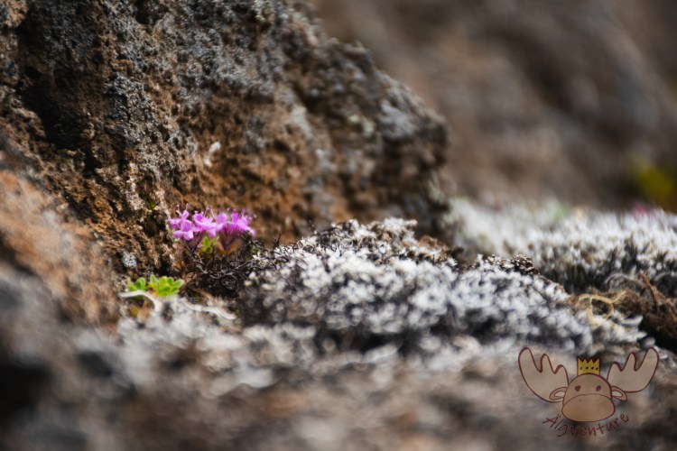
Dimmuborgir | Wer mit offenen Augen und Ohren durch die unwirklich wirkende Landschaft wandert, wird schnell merken wie sehr sie mit Leben gefüllt ist. – Anyone who wanders through the unreal landscape with open eyes and ears will quickly notice how full it is with life. 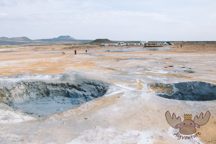
Námafjall Hverir 
Námafjall Hverir 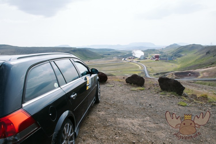
Krafla | Die Zufahrtsstraße führt direkt am Krafla-Kraftwerk vorbei. – The access road leads directly past the Krafla power plant. 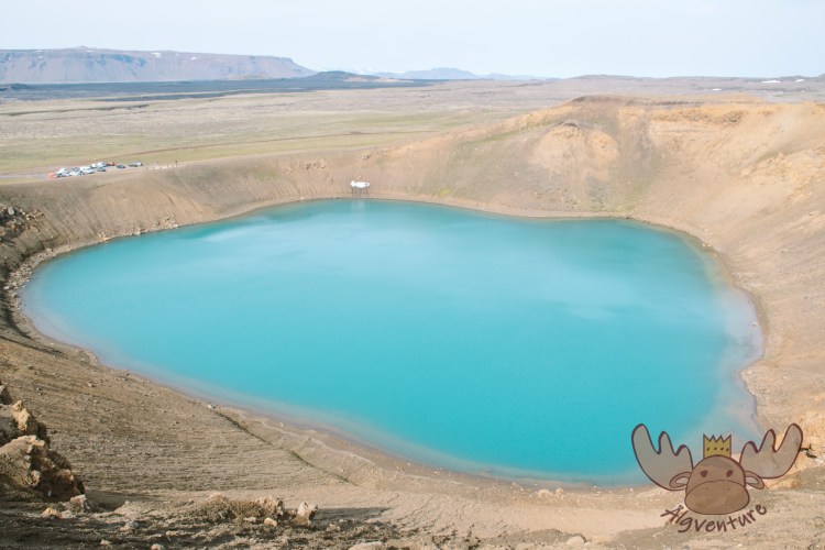
Krafla | Um den wunderschönen blauen See in der Mitte des Kraters führt ein Wanderweg. – A hiking trail leads around the beautiful blue lake in the middle of the crater. 
Krafla | Die ewige Dusche an der Zufahrtsstraße zum Krafla. – The eternal shower on the access road to Krafla.
The Mývatn region lies at the point where the Eurasian plate meets the American plate. A visible fissure, approximately 20 kilometers long, runs through the landscape. Near this crevice is also Grjótagjá, which was formerly used as a bathing grotto. Although swimming is forbidden here today, it is worth a visit even without jumping into the warm water. The cave was also used in the TV series “Game of Thrones” for the love scene between Jon Snow and Ygritte, as well as many other locations in Iceland. If you would like to bathe in the volcanically warmed water, you can do so in “Jarðböð”, which is not far from the cave.
Another sight of volcanic origin is the surreal world of the Dimmuborgir (dark castles). The tuff rock formations, which rise several meters into the sky, were created during a volcanic eruption over 2,300 years ago when liquid lava flowed over a lake and the resulting water vapor caused it to solidify in vents and caves. In Icelandic legend, Dimmuborgir is also seen as the place where many elves and trolls live.
You can find further information that is not shown on our site at northiceland.is.


Austurland
The easternmost region of Iceland is the entrance gate for everyone who comes to the island by ship. There are actually only two ways to get to Iceland. Either by plane at Keflavik Airport in the capital region not far from Reykjavik, or by ship from Denmark to the small town of Seyðisfjörður in Austurland. If you want to explore Icelandic nature with your own vehicle, you can do so with the Smyril Line. This ferry line offers car packages to travel on the MS Norröna. The respective departure times and the time for the stopover on the Faroe Islands can be found in the official timetable.
But Seyðisfjörður is by no means just a port for the ferry from Denmark. A number of artists have settled in the small town and run their studios or cafés along the famous and often photographed Rainbow Street. The Tourist Information Center in Seyðisfjörður offers a variety of activities right after you get off the ferry.
After arrival, the beautiful Icelandic landscape reveals itself as you drive from the small coastal town to Egilsstaðir, the largest and most important town in Austurland. The road leads along the valley over a mountain pass where you come across one of the first beautiful waterfalls, Gufufoss.


Not far from Egilstadir are the Hengifoss and Litlanesfoss, both of which are ideal for a leisurely hike. Starting from a parking lot, a hiking trail leads about 2.5km to Hengifoss and halfway there is Litlanesfoss. The first two kilometers are easy to manage, but in the upper part the hiking trail leads through rocky and sometimes impassable terrain. We advise you to plan enough time for both waterfalls, as there is much more to discover in the area.
During the high season, many people arriving in Iceland may experience parking problems at their first stop. About five kilometers away is the Vatnajökull National Park visitor center in Skriðuklaustur, which will be happy to provide you with further information about the other hiking options in the region.


Austurland is characterized primarily by small villages, narrow fjords, waterfalls and mountains. The nature and landscape are breathtaking and offer a wide range of outdoor experiences – such as the most beautiful hiking trails through the rugged and exciting highlands.
If you want to experience the Icelandic highlands without an off-road vehicle, you can at least partially do so on the many roads away from Hringvegur. The ring road is well developed throughout and leads quickly along the coast. However, the side roads in Austurland, which are often not asphalted but are still easy to drive on, lead through breathtaking mountain landscapes. However, be careful with roads with “F” added to their name, as these should only be driven on with off-road vehicles. You can find out the road conditions in advance on the vegagerdin.is website.
Although the rugged coast of Iceland has its own charm, we recommend leaving the ring road and instead taking road 95 and especially road 939 to immerse yourself in the Icelandic mountain landscape.
In the south of Austurland are the foothills of the Vatnajökull glacier. At the Jökulsárlón (iceberg lagoon) large chunks of ice break off the glacier tongue and fall into a lake of melted glacier ice to land in the sea with the current. These are often washed back onto the beach and give the impression that there are thousands of diamonds lying there.
The different coloring of the ice comes from different crystals in the ice and their reflection. The black on the pieces of ice is by no means a sign of man-made environmental pollution, but rather comes from volcanic ash that has settled on the ice. There are several hiking trails around the lake where you can observe the seagulls and seals that live there.
Many other sights in Austurland are just waiting to be explored. For even more information, visit the VisitAusturland website.

Suðurland
 For most travelers to Iceland, Suðurland will be the most interesting. Not because the other regions of Iceland have less to offer, but Suðurland is the easiest to reach from Reykjavik. The so-called “Golden Circle” runs from the capital, as the name suggests, in a circle past many landmarks worth seeing.
Following the Golden Circle clockwise, the first important landmark you come across is Þingvellir National Park. This place is a very important place for Iceland in many ways. The name Þingvellir is made up of the words Thing (gathering) and Vellir (fields or plain). The first settlers of Iceland held meetings with a judicial function once a year from the year 930 onwards. All male freemen (women, children and slaves were not allowed) from all over Iceland had to meet on this level. This place was also chosen because riding paths from all directions met here. Remains of old walls in the Almannagjá (Allmen’s Gorge) still bear witness to these meetings today. But Þingvellir is also a very important place geologically, as the Eurasian and American tectonic plates are continually drifting apart here. The national park invites its visitors to explore with extensive hiking trails and an informative visitor center.

Þingvellir | Seit dem Beginn der Landnahme in Island haben sich die Menschen an diesem Ort getroffen um über wichtige Dinge abzustimmen. – Since the beginning of the settlement of Iceland, people have met in this place to vote on important matters. 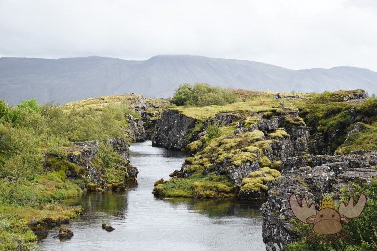
Þingvellir | Im Þingvellir-Nationalpark können Tauchgänge gebucht werden und man schwimmt zwischen den Kontinentalplatten. – In Þingvellir National Park you can book dives and swim between the continental plates. 
Þingvellir | Þingvallakirkja, die Kirche in Þingvellir, ist normalerweise geschlossen und kann nur im Zuge einer Führung mit einem der Ranger des Nationalparks besichtigt werden. – Þingvallakirkja, the church in Þingvellir, is normally closed and can only be visited on a guided tour with one of the national park rangers. 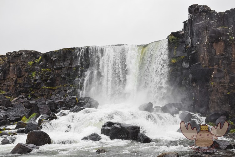
Þingvellir | Öxarárfoss
The Golden Circle continues to the famous geysers. The water-spouting wonders of Iceland’s volcanic landscape are one of the must-visit destinations. The Great Geyser, which also gives its name to all relatives of its kind around the world, only spits out large masses of water very irregularly, but its little brother Strokkur reliably blows water to lofty heights every 15-20 minutes.
The Gullfoss, just a few kilometers further, makes you seem very small due to its size and the enormous water masses. This is where the visitor really becomes aware of the power that lies in nature.

Geysir 
Geysir | Das geothermische Feld, in dem der Große Geysir liegt, erstreckt sich über eine Fläche von etwa 3 Quadratkilometer. – The geothermal field in which the Great Geyser lies covers an area of approximately 3 square kilometers. Geysir | Älgbert beobachtet in sicherer Entfernung von einem nahegelegenen Hügel aus den spektakulären Ausbruch des Strokkur. – Älgbert watches the spectacular eruption of Strokkur from a safe distance from a nearby hill. 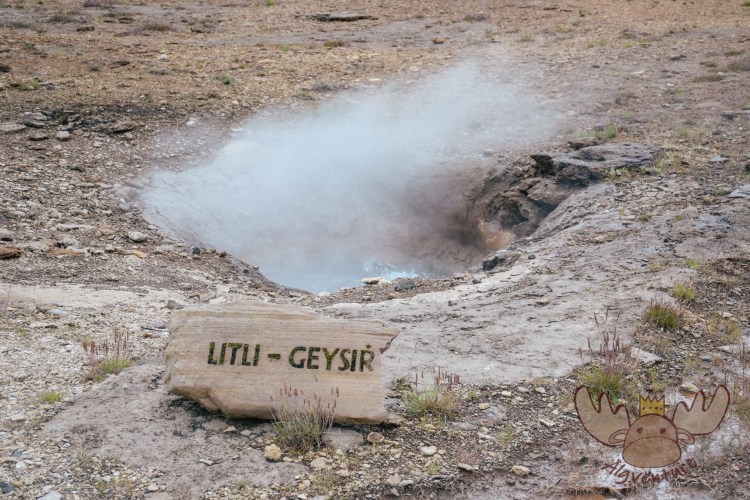
Geysir | Mehrere größere und kleinere Geysire, sowie Schlammtöpfe und Fumarolen befinden sich auf engem Raum beieinander und können vorsichtig erkundet werden. – Several larger and smaller geysers, as well as mud pots and fumaroles, are located in a small area and can be explored carefully. 
Geysir | Der kleinere Strokkur gleich neben dem Großen Geysir bricht verlässlich in regelmäßigen kurzen Abständen aus. – The smaller Strokkur right next to the Great Geyser reliably erupts at regular, short intervals.
The Golden Circle can also be done as a day tour from Reykjavik if you don’t spend too long at each station because of Iceland’s enormous beauty. There are also many operators in the capital that offer bus tours.
Due to the volcanic activity, Iceland can also use it to generate energy. One of these possible uses is to use the heat to heat the greenhouses in a cost-effective and environmentally friendly way. For example, it is possible that Iceland can cover around 70% of its own needs for tomatoes and almost 100% of its needs for cucumbers. But strawberries are also successfully grown, but they are so „holy“ that they are only eaten individually and sometimes only sold individually. Attempts have also been made to breed and cultivate bananas in Iceland, but so far they have been only moderately successful. At Friðheimar in Reykholt you can satisfy your hunger with these products right in the greenhouse there.
The next and final stop on the Golden Circle before heading back to Reykjavik is the approximately 3,000-year-old Kerið volcanic crater, in the middle of which is a picturesque lake. Many bus tours also make a stopover here, so it can happen that there are suddenly a lot of people there at the same time and shortly afterwards everything is empty again.
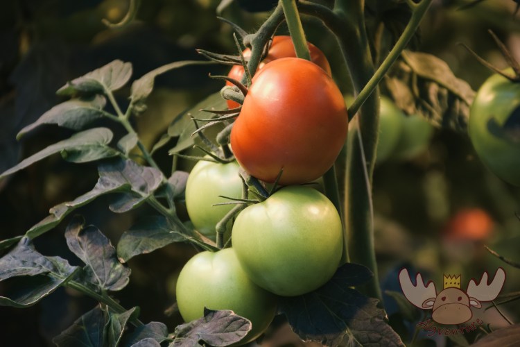
Friðheimar | Die Tomaten reifen mit der Kraft der Vulkane in Glashäusern. – The tomatoes ripen in glass houses using the power of volcanoes. 
Friðheimar | Wenn die Tomaten reif sind, können bis zu einer Tonne der Südfrüchte pro Tag in Friðheimar geerntet werden. – When the tomatoes are ripe, up to a ton of the tropical fruit can be harvested per day in Friðheimar. Friðheimar | Das Glashaus bietet ein einmaliges Ambiente um eine Frucht zu genießen, die man nicht in Island erwarten würde. – The Glasshouse offers a unique ambience to enjoy a fruit that you would not expect in Iceland. 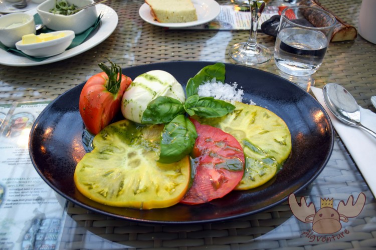
Friðheimar | Dies ist das Resultat der Arbeit Friðheimars und kann im angeschlossenen Restaurant verkostet werden. – This is the result of Friðheimar’s work and can be tasted in the attached restaurant. 
Friðheimar | Älgbert verkostet alle Produkte inmitten der Tomatenpflanzen. – Älgbert tastes all the products in the middle of the tomato plants.
But the Golden Circle is by no means the only thing Suðurland has to offer. We definitely recommend exploring this part of Iceland by car.
Just after the glacial lake Jökulsárlón from Austurland, the black foothills of the Vatnajökull glacier spread out to the sea. The first few kilometers you drive through a deserted landscape that seems to change completely after every bend. Barren black desert landscapes alternate with lush green hills, only to change after the next bend into a landscape of large glacier tongues that meander through scree. The moss-covered Eldhraun lava field near Kirkjubæjarklaustur looks like it comes from another planet. Only the south of Iceland is so unreally beautiful and diverse.
Vík í Mýrdal is probably one of the most photographed churches in Iceland. On the steep coast of the nearby Dyrhólaey peninsula there is the opportunity to observe puffins up close and admire the beautiful landscape.
You can find out more information on the official website here.


Please click on one of the icons to learn more about it.
Legal regulations
Iceland is not a member of the European Union, but is a member of the Schengen area, which means that nationals of most EU member states and other countries, including Germany, Austria and Switzerland, are not allowed to stay for up to 90 days within 180 days require visa.
To enter Iceland you need a valid passport or ID card. The passport must be valid for at least 3 months beyond the departure date.
The speed limit is staggered as follows:
– In urban areas: maximum 50 km/h
– outside town on asphalted main and secondary roads: maximum 90 km/h
– outside of town on unpaved main and secondary roads: maximum 80 km/h
Even though it should be a given not to drive a vehicle while drunk, there is a blood alcohol limit of 0.5 in Iceland.
The amount of the punishment depends on the level of alcoholism. If the alcohol level is between 0.8 and 1.2 per mille, the fine is at least 70,000 ISK (approx. 465€). If the alcohol level is over 1.2 per mille, the penalty can be up to 1 year in prison.
Lighting is also mandatory in Iceland. It is permitted to use either low beam or daytime running lights. Failure to comply with the lighting requirement could result in severe penalties.


The South of the North – A travel report
It was that time again – we were embarking on a new adventure. After our stay with the Queen in London a few weeks earlier, we were drawn out into the world again to explore it. Many blank spots on our travel map are just waiting to be discovered by us. The general direction of…

Sunset on the Dachstein – Dinner in the Austrian Alps
The Dachstein: The jewel of the Alps attracts nature lovers and adventure seekers alike. Experience the breathtaking beauty of the Alpine landscape, from rugged rock faces to glittering glaciers. Whether you are an experienced mountaineer or a leisurely hiker – the Dachstein has something for everyone. Via ferratas, summit tours or leisurely hikes: everyone will…
In search of elves and banana plantations – A trip to Iceland
Imagine standing on the edge of a gurgling geyser while steam fogs up your glasses. Or hiking through a lunar landscape of black sand, framed by snow-capped peaks. Sound like an adventure? Iceland is just that and much more!
Join me on my adventure to Denmark, Iceland and the Faroe Islands.
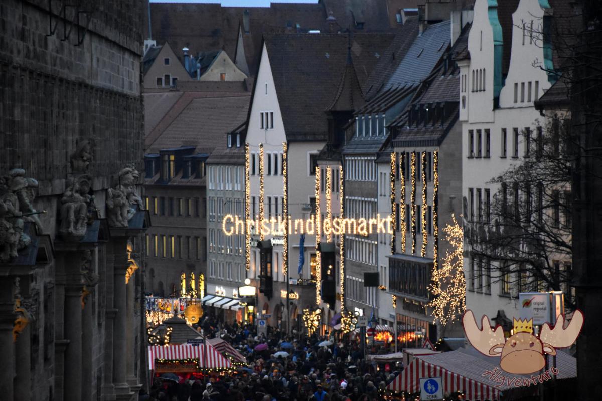
Christkindlesmarkt Nuremberg
Almost everyone has heard of him and many have seen him too. The Nuremberg Christmas market is one of the largest in Germany and we tell you about our visit.
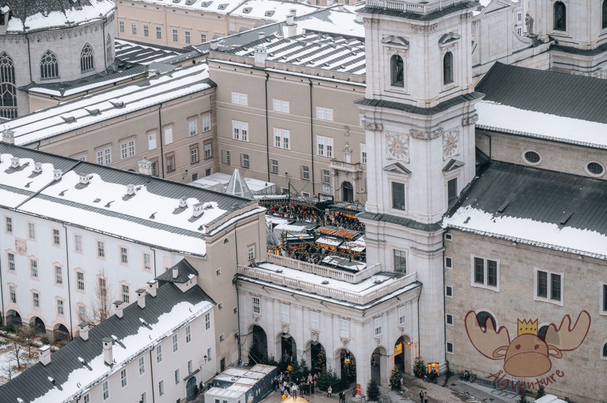
One weekend, four different Christmas markets – an exploration tour through the Austrian Christmas market tradition
The Christmas season is just around the corner and the various Advent markets want to get visitors into the Christmas spirit with their offerings. We’ll take you on our exploration tour to the most diverse representatives of Austrian Christmas market culture.
Etwas ist schiefgegangen. Bitte aktualisiere die Seite und/oder versuche es erneut.
