
An example of how to harness the unbridled power of a volcano.
Älgbert Elgson
Dieser Artikel ist auch in Deutsch verfügbar.
Krafla is a volcanic system about 100 km long in the north of Iceland. The central volcano with the same name and a height of 818 metres dominates the Mývatn region with numerous craters. The volcanic system also includes the nearby mud springs Hverarönd and the lava field Dimmuborgir.
The trail of history
The Leirhnjúkur area is a central volcano. A hundred thousand years ago, a volcanic cone stood here, which collapsed after an eruption. The resulting crater is now filled with younger volcanic material under which there is a magma chamber at a depth of about 3 km. Volcanic activity in the region occurs at intervals of several centuries. Magma flows into the chamber, which expands and lifts the ground. Then, due to the prevailing pressure, the chamber suddenly bursts and magma flows north or south through underground cracks. Some of the magma can then come to the surface in an eruption. When the pressure in the magma chamber decreases, the land quickly subsides again. This process repeats itself every few months over several years.
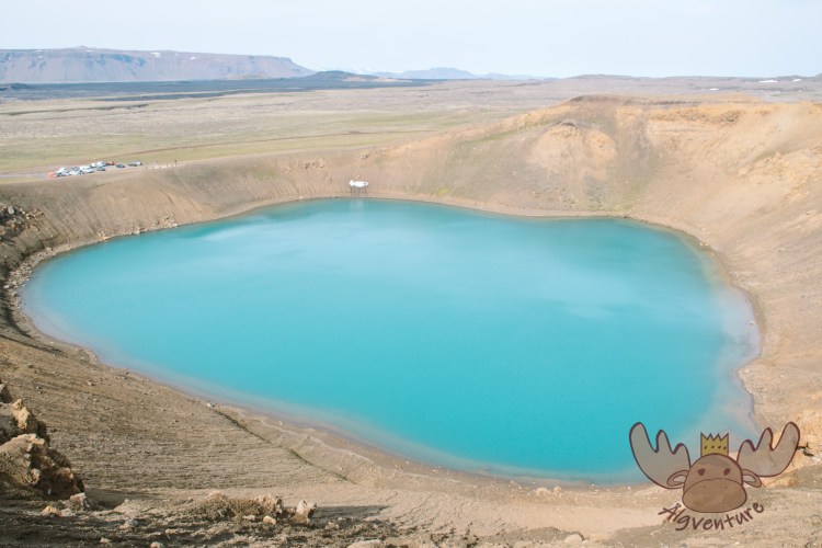
Krafla | Um den wunderschönen blauen See in der Mitte des Kraters führt ein Wanderweg. – A hiking trail leads around the beautiful blue lake in the middle of the crater. 
Krafla | Das Gebiet im Bereich des Zentralvulkans gilt als eines der interessantesten Wandergebiete Islands. – The area around the central volcano is considered one of the most interesting hiking areas in Iceland. 
Krafla | Wandernde Schafe – Hiking Sheep
The Mývatnseldar eruptions (the „Mývatn fires“) in 1724 began with a large volcanic explosion that formed the crater Víti. In the following years, a series of earthquakes and eruptions occurred near Krafla Mountain. The largest eruption took place in 1729, when lava flowed from Mount Leirhnjúkur down to Lake Mývatn. Eldhraun, the lava field between Reykjahlíð and Grímsstaðir, formed during the eruptions. After a break of about 250 years, a new series of eruptions began at Krafla in 1975. Nine eruptions occurred in the following nine years.
Lake Mývatn was formed when the lava field Laxárdalshraun blocked a river course in the Laxárdalur valley. Rainwater is quickly absorbed by the bedrock and comes to the surface as spring water. Lake Mývatn is one of these spring water areas. About 35 cubic metres of water flow every second from countless cold and warm springs on the shores of the lake. The water is rich in minerals and the main reason for the lake’s abundance of nutrients. With the help of the unusually rich sunlight for this area, many algae grow in the lake. The algae provide food for mosquito larvae and crayfish, which again are food for birds and fish.
Useful Information
The area around the central volcano is considered one of the most interesting hiking areas in Iceland. It is also one of the best developed hiking trails.
You can choose from a wide variety of easy and medium level hiking trails.
Easy hikes lead through the remains of the lava lake at Dimmuborgir or around and onto the pseudo-crater of Skútustaðir, as well as through the high-temperature area of Hverarönd or onto the Víti crater. Tours to Vindbelgjarfjall and around and up Leirhnjúkur and from there down to the lake at Reykjahlíð in about five hours are of medium difficulty.
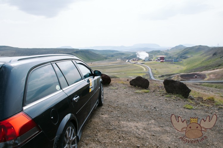
Krafla | Die Zufahrtsstraße führt direkt am Krafla-Kraftwerk vorbei. – The access road leads directly past the Krafla power plant. 
Krafla | Das Vulkansystem des Krafla wird intensiv zur Energiegewinnung genutzt. – The Krafla volcanic system is used intensively to generate energy. 
Krafla | Das heiße Wasser wird mit Hilfe von Rohrleitungen zum Kraftwerk geleitet. – The hot water is piped to the power plant. 
Krafla | Die ewige Dusche an der Zufahrtsstraße zum Krafla. – The eternal shower on the access road to Krafla.
On the way to the Víti crater there is a small inconspicuous shower at the side of the road.
This inconspicuous source of warm water is fed by the volcanic system and attracts many tourists as well as many mosquitoes. These are basically harmless, but they can get on your nerves a lot after a while. Both.
The lava formations can be easily damaged and you have to be especially careful in the geothermal areas. Therefore, it is forbidden to hike off the marked trails or to drive off the roads.
How to get there?
The ring road passes directly by Krafla. Near the village of Reykjahlíð, at the Hverir mud springs, there is a turnoff onto the road that leads to the Krafla power station Kröflustöð. At the end of this road is a car park which is also the starting point of many hiking trails in the area.
Conclusion
The area is very suitable for extended hiking tours, but you should never leave the marked paths here. From the circular trail on the crest of the crater, you have a beautiful panoramic view of the area.


The South of the North – A travel report
It was that time again – we were embarking on a new adventure. After our stay with the Queen in London a few weeks earlier, we were drawn out into the world again to explore it. Many blank spots on our travel map are just waiting to be discovered by us. The general direction of…

Sunset on the Dachstein – Dinner in the Austrian Alps
The Dachstein: The jewel of the Alps attracts nature lovers and adventure seekers alike. Experience the breathtaking beauty of the Alpine landscape, from rugged rock faces to glittering glaciers. Whether you are an experienced mountaineer or a leisurely hiker – the Dachstein has something for everyone. Via ferratas, summit tours or leisurely hikes: everyone will…
In search of elves and banana plantations – A trip to Iceland
Imagine standing on the edge of a gurgling geyser while steam fogs up your glasses. Or hiking through a lunar landscape of black sand, framed by snow-capped peaks. Sound like an adventure? Iceland is just that and much more!
Join me on my adventure to Denmark, Iceland and the Faroe Islands.
One weekend, four different Christmas markets – an exploration tour through the Austrian Christmas market tradition
The Christmas season is just around the corner and the various Advent markets want to get visitors into the Christmas spirit with their offerings. We’ll take you on our exploration tour to the most diverse representatives of Austrian Christmas market culture.
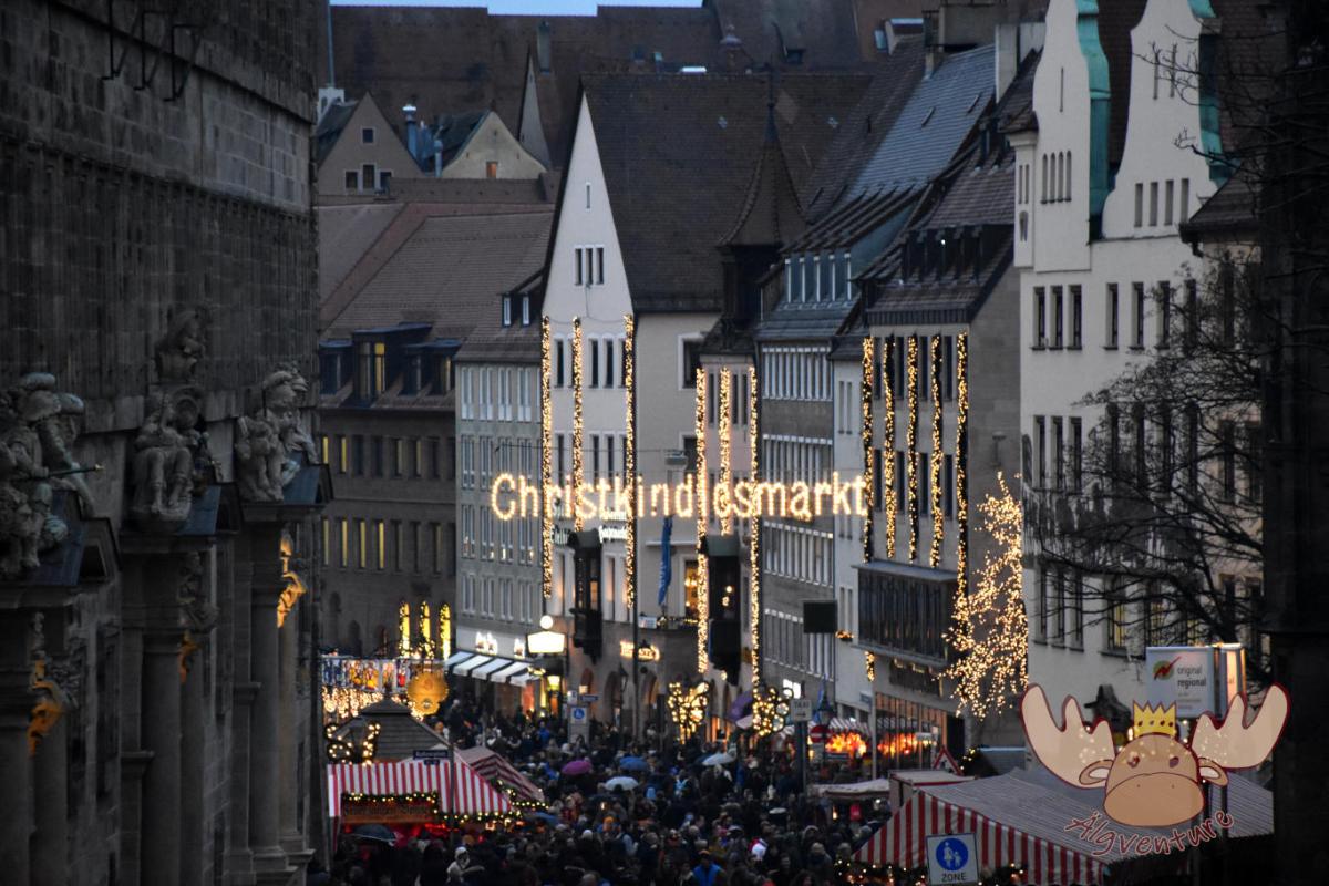
Christkindlesmarkt Nuremberg
Almost everyone has heard of him and many have seen him too. The Nuremberg Christmas market is one of the largest in Germany and we tell you about our visit.
Etwas ist schiefgegangen. Bitte aktualisiere die Seite und/oder versuche es erneut.
